
Topic overview
Briefly
- Denver International Airport recorded 100 degrees on Saturday, marking the sixth day this year with such high temperatures.
- A Heat Advisory is in effect for the northern I-25 Corridor and Denver metro through 8 p.m. Sunday.
- The extreme heat is expected to continue into early next week, but a significant cooldown is forecasted for later in the week.
What happened
In the United States, particularly in Colorado, the weather has been exceptionally hot, with Denver International Airport recording a temperature of 100 degrees on Saturday, marking the sixth day this year that temperatures have reached or exceeded this threshold. This ties with the year 2024 for the number of 100-degree days recorded in a single year, although the all-time record for Denver stands at 13 days, set in 2012. The month of August has started off with a significant heat wave, as the city has experienced triple-digit temperatures three times in the past week.
Sunday has been designated as a First Alert Weather Day due to the ongoing heat, with a Heat Advisory in effect for the northern I-25 Corridor and the Denver metro area until 8 p.m. The primary concern for the day is the high temperatures, but there is also a forecast for a few showers and isolated thunderstorms developing in the afternoon. While these storms are not expected to bring substantial rainfall, they could produce strong, gusty winds, with gusts ranging from 30 to 45 mph and isolated gusts potentially reaching up to 55 mph.
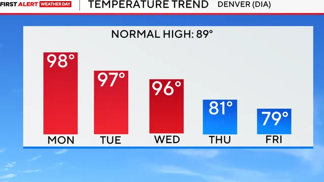
The heat is not expected to break immediately, as Monday and Tuesday will continue to see very warm temperatures, with highs again reaching the mid to upper 90s across the Denver metro area. However, a cooling trend is anticipated to begin on Wednesday, with temperatures dropping into the lower 90s. The most significant cooldown is expected to arrive on Thursday, continuing into the following weekend. Forecasted highs will trend into the 70s and 80s in many locations, coinciding with the return of monsoon moisture, which will bring more widespread chances for showers and thunderstorms. Some of these storms could produce heavy rainfall, raising concerns about potential flooding in certain areas.
Overall, the extreme heat and subsequent weather changes highlight the ongoing challenges posed by climate conditions in Colorado, particularly during the summer months. The combination of high temperatures and the potential for severe weather underscores the importance of monitoring local forecasts and taking necessary precautions to ensure safety during such weather events.

Comprehensive report
Full story,
in detail.
Trace the developments that led here, see how the story evolved, and understand the forces and wider context surrounding it.