
Topic overview
Briefly
- A flood watch is in effect until 8 a.m. Monday, excluding areas north of Pittsburgh except Beaver
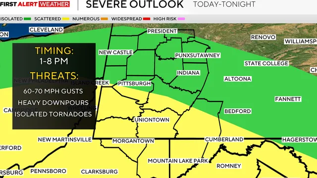
- Areas south of Pittsburgh face a slight risk of severe storms with damaging winds after 1 p.m.
- Cooler, drier air arrives Tuesday with highs in the upper 70s and low 80s for the rest of the week
What happened
The Pittsburgh area is bracing for a day of severe weather on Sunday, August 16, 2026, with multiple rounds of heavy rain and the potential for isolated tornadoes. A tornado warning has been specifically issued for parts of Beaver and Butler counties, remaining in effect until 3:45 p.m. This alert is part of a broader KDKA First Alert Weather Day designation, indicating a high-impact weather event. The primary threats include damaging winds and the possibility of an isolated tornado, particularly for areas south of Pittsburgh, which are under a slight risk for severe weather, a level 2 out of 5 on the severity scale. This heightened risk period is forecast to begin after 1 p.m. and persist through the afternoon.
A flood watch is also in effect for much of the region, lasting until 8 a.m. on Monday. This watch, however, excludes areas north of Pittsburgh, with the notable exception of Beaver County. The day's weather pattern is expected to feature several distinct waves of precipitation. Following an initial round of rain, a brief lull is anticipated in the late morning before the next, more intense round of storms moves in, lasting until approximately 8 p.m. The combination of heavy rainfall and severe storm potential creates a hazardous situation for residents, with the primary concerns being flash flooding in low-lying areas and structural damage from high winds or a tornado.
The severe weather is being driven by a dynamic atmospheric setup that is conducive to rotating storms. The slight risk category for areas south of Pittsburgh indicates a higher confidence among meteorologists that some storms will become severe. The specific mention of an isolated tornado risk after 1 p.m. suggests that wind shear, a change in wind speed and direction with height, will be sufficient to allow supercell thunderstorms to develop. These are the type of storms most likely to produce tornadoes. The flood watch, separate from the severe thunderstorm risk, is a response to the anticipated multiple rounds of heavy rain, which could overwhelm drainage systems and cause rapid rises on small streams and creeks.
Looking ahead, the active weather is expected to wind down significantly by Monday, with only a few stray showers lingering. A major pattern shift will then bring cooler and drier air into the region starting Tuesday. Temperatures are forecast to drop into the upper 70s and low 80s for much of the upcoming week, a notable change from the daily average high of 82 degrees. Humidity levels will also be low, providing a comfortable stretch of weather. The next chance for showers and thunderstorms is not expected until Wednesday evening, offering a multi-day reprieve after Sunday's severe weather threat.

Comprehensive report
Full story,
in detail.
Trace the developments that led here, see how the story evolved, and understand the forces and wider context surrounding it.