
Topic overview
Briefly
- Two disturbances bring scattered to numerous showers and storms on Sunday.
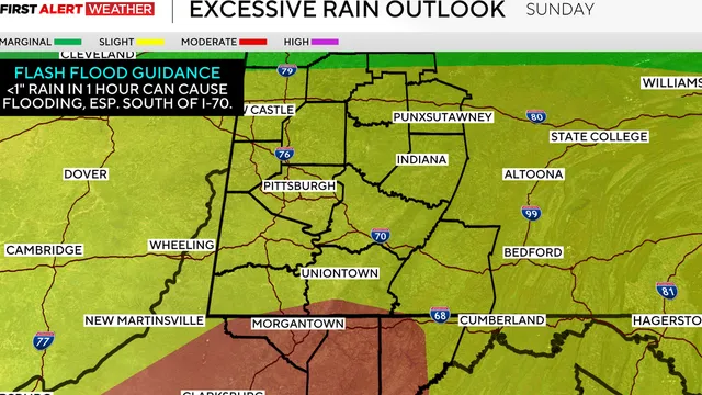
- Flash flood risk is highest south of I-76 into Northern West Virginia due to saturated soils.
- A second round of thunderstorms after 2 p.m. may include isolated tornadoes and wind damage.
What happened
The Pittsburgh area is under the influence of two disturbances that will bring scattered to numerous showers and thunderstorms on Sunday, August 16, 2026. The first round is expected during the early morning hours, associated with a warm front, and will be most widespread with heavier rainfall. After a lull between 9 and 10 a.m., a second shortwave will approach from the west, triggering another round of thunderstorms after 2 p.m. The atmosphere contains unusually high moisture content, and soils are already saturated, especially south of I-76 into Northern West Virginia, increasing the risk of flash flooding. A level-three (out of four) excessive rainfall risk is in place for these areas. The storms may be linear or discrete, with low-level wind shear sufficient for some rotation, particularly near and south of the turnpike where an outflow boundary from the first round will be present. A tornado threat is very isolated and low-end. Wind damage, including downed trees and power lines, is possible due to saturated soils. Most areas will receive 0.5 to 1.5 inches of rain, with isolated amounts up to two to three inches, especially in the southern third of the forecast area. After sunset, the severe weather potential wanes, and showers diminish overnight. Fog is possible Monday morning, with humidity persisting until a cold front passes from northwest to southeast between 9 a.m. and 2 p.m., possibly triggering isolated showers. Drier air arrives Tuesday morning. Wednesday brings another cold front and jet stream energy, causing more showers and storms in the afternoon and evening, with lingering showers Thursday. Later next week, highs will be in the mid to upper 70s, lows in the mid-50s to near 60, and more showers possible next weekend.

Comprehensive report
Full story,
in detail.
Trace the developments that led here, see how the story evolved, and understand the forces and wider context surrounding it.