
Topic overview
Briefly
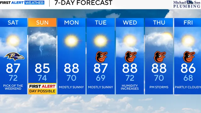
- Saturday brings sunny skies and upper 80s across Maryland.
- Sunday system brings heavy rain, storms, and isolated tornado risk.
- Drier and warmer weather returns Monday through Thursday.
What happened
The weekend weather across Maryland is set to shift dramatically from a pleasant Saturday to a potentially hazardous Sunday. Saturday will bring mostly sunny skies and seasonable afternoon temperatures in the upper 80s, offering residents a calm start to the weekend. However, a new weather system is expected to move into the region as early as Sunday mid-morning, beginning in Western Maryland. This system will bring heavy rainfall and embedded thunderstorms, with more storms likely later in the afternoon. The National Weather Service has designated Sunday as a First Alert Possible Day, indicating a heightened risk of severe weather. The primary concerns are heavy rainfall that could lead to flooding, along with the possibility of a few strong to severe thunderstorms. An isolated tornado risk exists for Sunday afternoon, adding to the potential for dangerous conditions. Due to the cloud cover and steady rainfall, temperatures on Sunday will be kept below seasonable highs, only reaching the upper 70s to lower 80s. This is a notable drop from the previous day's warmth. The storm system is expected to move through the state, but the exact timing and intensity may vary, so residents are advised to stay updated on forecasts and be prepared for changing conditions. After the unsettled Sunday, a drier pattern is forecast to return for the start of the work week. From Monday through Thursday, afternoon temperatures will reach into the upper 80s, near the seasonable high for this time of year, with limited rain chances. However, by Thursday afternoon, rain chances increase again with a chance of showers and storms. Cooler temperatures are expected to move in by the end of the week and into the following weekend, with afternoon highs in the lower 80s and only isolated showers possible. This pattern suggests a return to more typical late-summer weather after the brief but significant storm event on Sunday.

Comprehensive report
Full story,
in detail.
Trace the developments that led here, see how the story evolved, and understand the forces and wider context surrounding it.